Boutique Agency

14 January 2026
Just north of Nice, near the picturesque villages of Aspremont and Tourrette-Levens, lies one of the region’s most beautiful hiking routes: the Tour du Mont Chauve. This is no ordinary forest walk, but a sporty hike rewarded with stunning views.
Why this hike is so special
From various points along the route, you enjoy sweeping views over the Baie des Anges, the Mediterranean Sea, and the majestic Alps to the north. On clear days, you can even spot Corsica on the horizon!
The name Mont Chauve refers to two “bare” summits: Mont Chauve d’Aspremont (853 m) and Mont Chauve de Tourrette (785 m). The higher peak is crowned by the impressive Fort du Mont-Chauve, built in the late 19th century as part of the defensive ring protecting Nice.
The trail winds through Mediterranean holm oak forests (evergreen oaks), across ancient terraces and worn paths, alternating between open panoramic sections and cooler, shaded stretches.
This route combines physical challenge with plenty of scenic rest points — ideal for those who enjoy effort with a reward, as the views continuously recharge your energy.
During the Tour du Mont Chauve, you literally follow centuries-old boundary lines once used by soldiers, shepherds, and traders.
Route at a Glance
📍 Start & finish: Aspremont (approx. 14 km from Nice)
📏 Distance: ± 8.4 km
🕒 Duration: ± 3 hours (excluding breaks)
⬆️ Elevation gain/loss: ± +460 m / –460 m
📌 Difficulty: Medium – a good level of fitness is recommended. Dogs are welcome.
The hike starts in the village of Aspremont, at around 500 metres altitude. After a gentle start through the village, the path climbs steadily along the old GR®5 trail, then continues over panoramic ridges toward the summit. Along the way, you pass several viewpoints with beautiful vistas over the Var Valley and the lower Mediterranean coastline.
Interesting Facts Along the Way
The fort forms part of the Séré de Rivières defensive system from the 1880s, designed to protect Nice and its northern access routes. Today, the site is used by civil aviation services.
Although Mont Chauve literally means “bald mountain,” the name likely derives from the older term moun cau, gradually transformed over centuries.
The circular route loops around both Mont Chauve peaks, offering constantly changing terrain and perspectives.
Aspremont sits at around 500 metres above sea level and is aptly nicknamed the balcon de Nice. The village overlooks the Baie des Anges and marks the transition between the coast and the pre-Alpine landscape.
First mentioned in the 11th century, it developed as a fortified settlement controlling access to Nice. Thanks to its elevation, temperatures are often slightly cooler than along the coast — a welcome relief in summer. The surrounding slopes were historically used for olive cultivation and small-scale farming, and many old stone terraces remain visible today. From the village square, views extend as far as Cap d’Antibes on clear days.
Located slightly further inland, Tourrette-Levens has an even stronger medieval character. Built around an impressive castle, it overlooks the Banquière Valley.
The Château de Tourrette-Levens, dating back to the 13th century, played a key role in the defence of Nice and now houses a museum and an international chess collection. The village is known as the village des échecs (village of chess), with chess motifs and installations scattered throughout. More sheltered than Aspremont, it offers cooler, forested paths and has long stood at the crossroads of Savoyard, Piedmontese, and Provençal influences.
Practical Tips for Hikers
Several parking areas are available in Aspremont, including near the football field or close to the trailhead. Availability is generally good, especially outside peak hours.
In spring and winter, bus line 76 runs from Nice to Aspremont. Always check the current timetable in advance.
Sturdy hiking shoes are essential due to steep and rocky sections.
Bring enough water and snacks — there are no facilities along the route.
Many sections are exposed; sunscreen and a hat are strongly recommended.
A GPS or map can be useful but is not essential, as the route is reasonably well marked.
Route Description
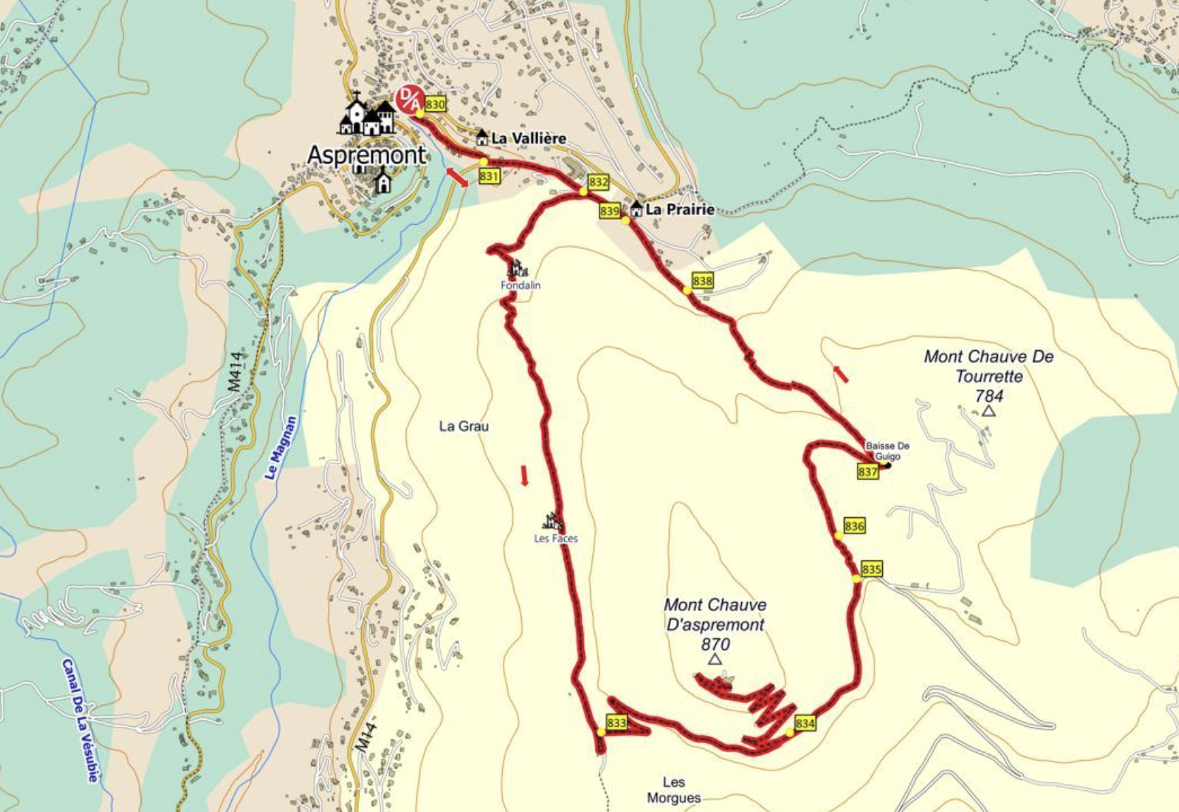
From the Aspremont car park (500 m), take the Vallière footpath downhill, running parallel to the road towards Nice (Gairaut – marker 830). Quickly cross the road and continue straight on the wide Campoun path (marker 831) until you reach a fork.
Take the right-hand path, following the GR®5, which climbs above the village of Aspremont via a series of rocky hairpin bends (marker 832), set on a sunny hillside.
This leads to a panoramic viewpoint overlooking the Var Valley. The route then becomes easier, following a long, almost level traverse across old terraces (south-facing) to the foot of the bastion on the summit of Mont Chauve d’Aspremont (marker 833).
Turn left onto the DFCI fire-prevention track of Les Morgues, which soon crosses a small paved military road (marker 834). Passing through holm oak forest, the route climbs via eight panoramic hairpin bends to the fort at the summit, surrounded by antennas and satellite dishes.
Descend back to the road as far as a barrier (marker 835), then take the path on the left, which returns via the Col de Guigo (747 m – marker 837) toward the village. Complete the loop via the Bergerie path, followed by Chemin du Campoun and Chemin de la Vallière, retracing the approach route (markers 838, 839).
This site is protected by reCAPTCHA and the Google Privacy Policy and Terms of Service apply.